Walking Florence historic streets: insider guide
Why Florence rewards walking on foot
Florence is compact enough to cover entirely on foot, and dense enough that a single street of 200 metres may contain more architectural information than an entire city block in most other Italian cities. The historic centre, inscribed as a UNESCO World Heritage Site since 1982, covers an area of about 500 hectares. From Piazzale Michelangelo to the train station is roughly 3 kilometres. From the Duomo to Porta Romana is about 1.5 kilometres. Most visitors walk far less than this and see a fraction of what is available.
The city’s street plan is largely medieval. The Roman grid underlying the oldest part of the centre, around Piazza della Repubblica, has been visible in the street names since the 19th century, but most of the lanes branching off the main thoroughfares follow alignments established between the 11th and 14th centuries, when Florence was expanding rapidly and absorbing its surrounding countryside. Many of these streets are less than four metres wide. Some are barely passable by a single car.
Walking them requires attention to what is above eye level. The ground floors of most palaces are either blank rusticated stone or have been converted into shops. The interest is in the first and second floors: the carved stone window surrounds, the carved coats of arms on the facades, the iron fixtures for flagpoles and torch holders, and the occasional loggia or overhanging cornice. A small pair of binoculars is not unreasonable for close examination of upper-story details.
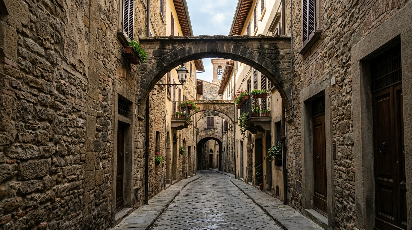
Walk 1: the medieval streets north of the Duomo
Begin at the corner of Via dei Servi and Via dei Pucci, roughly 300 metres north of the Duomo. Via dei Servi runs from Piazza Santissima Annunziata south to the cathedral, and its western side is lined with significant 15th and 16th-century palaces. The Palazzo Niccolini, at number 15, was built in the 1550s to a design attributed to Baccio d’Agnolo. Its facade, with paired columns framing the central bay, is an early example of classical order applied to a domestic building in Florence.
Turn west onto Via de’ Pucci. This short street connects to Via Cavour, but before it does you pass the Palazzo Pucci, home of the fashion house founded in 1947 by Emilio Pucci. The building dates from the 15th century, and the family has owned it continuously for over 500 years, one of the few genuine examples in Florence of an unbroken aristocratic residential occupation. The interior is not publicly accessible, but the courtyard can sometimes be seen through the main entrance.
Continue west on Via Cavour and then south along Via dei Ginori. The Palazzo Ginori, at number 11, was built in the early 16th century and exemplifies the Florentine Renaissance domestic palace type: rusticated ground floor, piano nobile with pedimented windows, and a roofline cornice in grey pietra serena. The street is quiet enough at most hours to allow a proper examination without being pushed along by pedestrian traffic.
Walk 2: Oltrarno south of Ponte Vecchio
Cross Ponte Vecchio heading south and turn immediately right onto Via de’ Bardi. This is one of the oldest streets in Oltrarno, following the base of the slope below the Bardini Garden. The street is only about four metres wide and is flanked by medieval tower-houses and Renaissance palaces in a compressed sequence. Several buildings show the distinctive corbelling and projecting upper stories that characterise medieval Florentine domestic architecture.
At number 36, you pass the Palazzo Capponi alle Rovinate, built in the early 15th century. The building takes its informal name from the landslides (rovinate) that periodically threatened this part of the street due to the unstable clay beneath the slope above. The garden wall above the street on the right is part of the Bardini Garden, which covers roughly 4 hectares and offers a different perspective on the city than the more famous Boboli.
Continue along Via de’ Bardi until it becomes Via de’ Mozzi, and then turn left up Costa San Giorgio. This steep lane climbs toward Forte Belvedere, passing the house at number 19 where Galileo Galilei lived from 1610 to 1631, marked by a commemorative plaque. The street surface is original cobblestone, worn smooth but still functional. The views across rooftops increase as you climb. The walk from Via de’ Bardi to the top of Costa San Giorgio takes about 20 minutes at a slow pace.
Walk 3: the artisan streets of western Oltrarno
Begin at Piazza del Carmine and walk west along Borgo San Frediano. This street functions as the main artery of the neighbourhood’s artisan economy. Between numbers 30 and 80, you pass active workshops: furniture restorers, gilders, woodworkers, upholsterers, and at least two or three antique dealers whose interiors are piled with unrestored objects. Many workshops have their doors open during working hours (generally 9:00 to 13:00 and 15:00 to 19:00, Monday to Saturday).
The Porta San Frediano, at the western end of Borgo San Frediano, is one of the best-preserved medieval city gates in Florence. Built in 1324, it stands about 18 metres high and has a wooden door original to the 14th century. The gate marks the boundary of the 13th-century city walls. Beyond it, the road continues toward Scandicci and the western suburbs.
Return east along Via Santa Monica and Via Sant’Agostino to reach Piazza Santo Spirito. The church of Santo Spirito, facing the piazza, was designed by Filippo Brunelleschi in 1444 and completed after his death. The facade was never given its intended finish and remains plain white render, which Brunelleschi’s biographer Manetti described as a betrayal of the architect’s intentions. The interior, however, is fully realised: a nave with 35 chapels, each containing an altarpiece commissioned from a different 15th or 16th-century painter, creating an anthology of Florentine Renaissance art outside the museum system.
Walk 4: the backstreets between Santa Croce and the Arno
Begin at Santa Croce and walk south toward the Arno along Via de’ Benci. Turn right onto Lungarno delle Grazie and then left onto Via dei Renai. This part of the south bank east of Ponte alle Grazie is less visited than the central Oltrarno. The streets are residential and the pace is different. Via dei Renai takes its name from the sand merchants (renai) who unloaded building materials here from boats on the Arno in the medieval period.
Turn south from Via dei Renai onto Via dell’Olmo and then west along Via dei Serragli, one of the longest streets in Oltrarno, running from Via de’ Renai all the way to Porta Romana. The street is 1.4 kilometres long and changes character several times along its length, from residential near the river to more commercial near the Porta Romana. At number 69, you pass the Villa il Tasso, a 16th-century suburban villa now absorbed by the urban fabric.
Continue to Piazza della Calza, immediately north of Porta Romana. The gate here, the Porta Romana, is the most monumental of Florence’s surviving medieval city gates, built in 1326. The arch spans about 7 metres and the gate tower is approximately 20 metres high. The dirt road leading south from the gate is the beginning of the Via Romana, which led in the medieval period toward Siena and Rome.
Walk 5: the Lungarni and the riverside
The embankment roads flanking the Arno, the Lungarni, were built in the 19th century on the orders of the Lorraine grand dukes and later completed under the unified Italian state. They replaced a medieval edge of buildings that came down to the water. The result is a wide, car-heavy road that is less pleasant to walk than the interior streets, but the river views and the facades visible from the opposite bank compensate for the traffic.
The stretch from Ponte Amerigo Vespucci in the west to Ponte alle Grazie in the east on the south bank offers the most coherent view of the historic Florentine skyline: the Duomo dome and campanile, the tower of Palazzo Vecchio, the profile of the Badia Fiorentina, and in the foreground the roofline of Ponte Vecchio. The best light is in the late afternoon, between 17:00 and 19:00, when the sun is behind you looking north and the stone facades on the opposite bank catch direct illumination.
Ponte alle Grazie, the easternmost bridge in the historic section, was destroyed in the German retreat of August 1944 and rebuilt in a plain post-war concrete design in 1957. It is not beautiful but it offers an unobstructed view up the river toward the Arno bend south of the city. The other bridges in this section, Ponte Vecchio, Ponte Santa Trinita, Ponte alla Carraia, and Ponte Amerigo Vespucci, were all rebuilt after the war to their original designs or close to them.
Where to stay
For walkers who want to use Oltrarno as a base for these routes, the south bank eliminates crossing the Arno for every excursion into the neighbourhood’s streets and reduces the distance to starting points on the north bank to five or ten minutes by foot. Accommodation in the heart of the district is provided by De’ Medici, within reach of all the itineraries described above.