Historical curiosities in Oltrarno Florence: a guide
The stone furniture of Oltrarno streets
Florentine Renaissance palazzi have stone benches built into their street-level facades: long horizontal slabs projecting from the rusticated base course, running the full width of the building. These are called sporti or sedili, and they were not decorative features but functional street furniture, required by civic ordinance in the 15th century. Property owners were obliged to provide seating along their frontages as a form of semi-public amenity. The benches were used by the workers and servants of the household during the day and by anyone who needed to rest. Several intact examples survive in Oltrarno: the Palazzo Pitti facade, the Palazzo Capponi on Via de’ Bardi, and the Palazzo Guicciardini on Via Guicciardini all retain them.
The rings embedded in the stone work at various heights on the same palace facades served a different purpose: they were used to tether horses, to attach temporary awnings, or to hang lanterns during public celebrations. The higher rings, some set three to four metres above street level, were used during the medieval period for routing ropes during the Scoppio del Carro ceremony and similar public rituals. The rings have outlasted the practices they served and are now simply iron fixtures in the stone, easy to miss.
A third category of street-level stone detail is the corner protection: heavy stone blocks projecting outward from the building corners at wheel height, designed to prevent the iron-rimmed wheels of heavy carts from damaging the building’s stonework. These paraspigoli are particularly visible on the corners of Via de’ Serragli and the side streets leading west from Piazza di Santo Spirito.
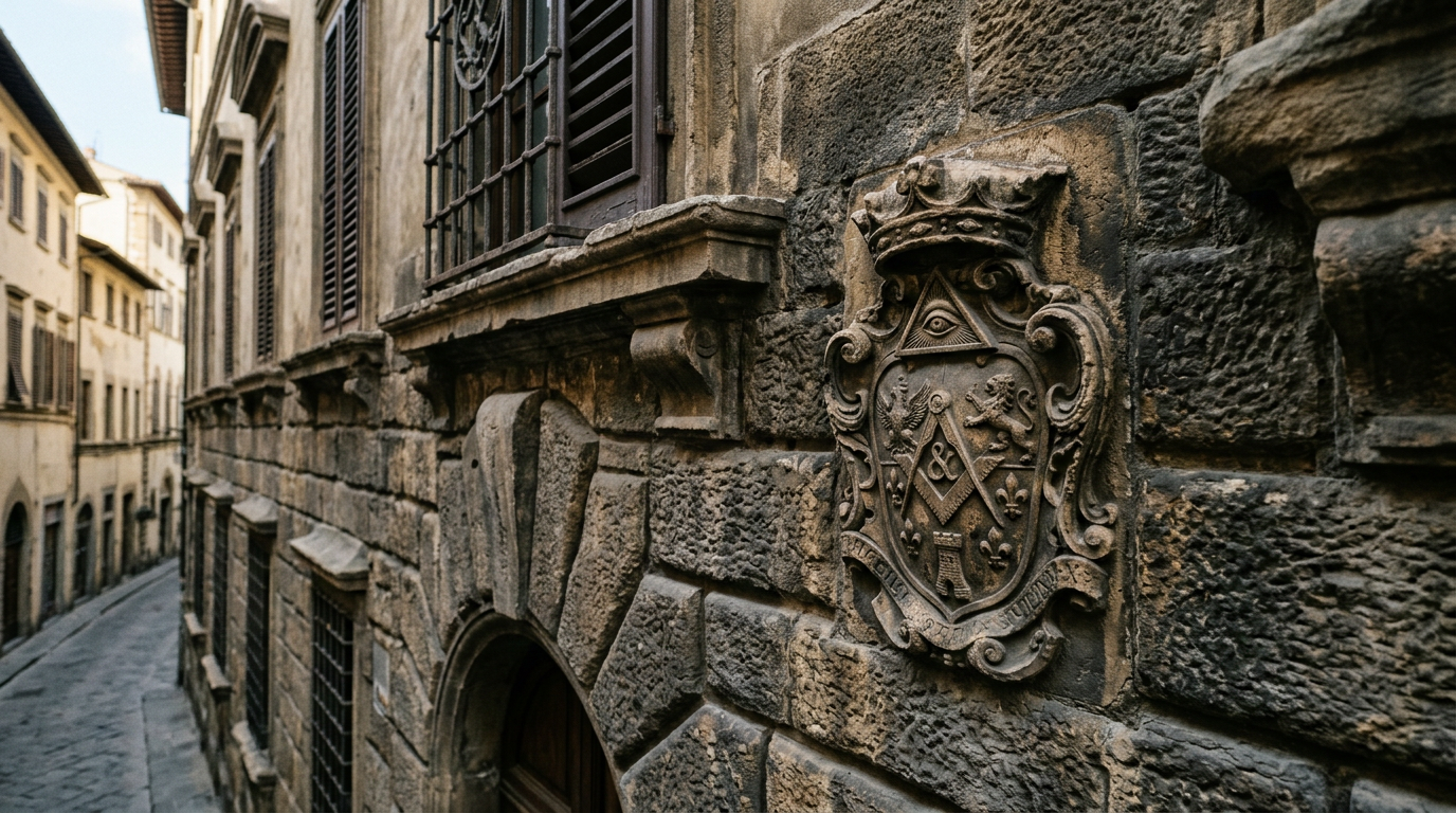
Heraldic markers and family territories
The facades of Oltrarno palazzi carry the heraldic shields of their builder families carved directly into the stone, typically above the main portal and sometimes repeated along the frieze course at each floor level. These are not purely decorative: in a city where family alliances, feuds, and territorial claims structured daily political life, the visible display of heraldry served as a claim to neighbourhood identity.
The Capponi family shield, a head of a Moor with a white headband on a blue field, appears on multiple buildings between Via de’ Bardi and Borgo San Jacopo. The Guicciardini shield (two horizontal bands per pale, with a specific ornament that varies by branch) is concentrated on Via Guicciardini. The Frescobaldi, one of the great banking families of medieval Florence, marked their tower complex at the north end of Via Maggio. Their tower no longer stands, but the foundation courses of the base can still be identified from the cut stone at street level.
The tabernacles, small shrines set into the corners of buildings or recessed into the wall above street level, are another form of territorial marking. Oltrarno has a high density of these corner shrines, most of them containing ceramic images of the Madonna. They were maintained by the street’s residents as a collective act of neighbourhood devotion, and they served as informal markers of administrative boundaries between parishes and contrade.
The Vasari Corridor’s street presence
The Corridoio Vasariano, built in 1565 to connect the Palazzo Vecchio to the Palazzo Pitti via a raised covered passage, crosses the Arno on the Ponte Vecchio and then runs along the roof-line of the buildings on Borgo San Jacopo before cutting through the Palazzo Mannelli and continuing to the Pitti. Its presence on Borgo San Jacopo is visible as a continuous brick-and-plaster box, elevated on brackets above the street, breaking through the corner of the Palazzo Mannelli rather than navigating around it (because the Mannelli family refused to sell the corner of their building, Vasari simply pushed the corridor through it, a bureaucratic power that architectural histories routinely note as significant).
The small windows set at regular intervals along the corridor’s exterior on Borgo San Jacopo, roughly twenty-centimetre square openings with iron bars, are the windows from which the Medici family could look down at the street without being seen. The Corridor is closed for ongoing restoration in 2026 and no internal visits are possible, but the exterior on Borgo San Jacopo, traversed by hundreds of pedestrians daily, is completely accessible.
Water management and the hydraulic city
The Arno’s behaviour dominated Oltrarno’s urban development for centuries. The river floods reliably in late autumn, and the flood of November 4, 1966, which reached 6.7 metres above normal level and inundated the entire historic centre, left flood markers on buildings throughout the neighbourhood. These brass plaques, typically reading “Alluvione 4 novembre 1966” with a horizontal line indicating the water level, are set at heights that still surprise visitors who see them: on Via de’ Bardi, the 1966 level reaches above a standing person’s head. The plaques are present on dozens of buildings; they turn the street into a continuous document of the disaster.
Older flood markers from earlier events, 1844, 1740, 1547, appear on some buildings in smaller formats, sometimes in Latin, sometimes integrated into the building’s stone course as a simple incised line. The most comprehensive collection of documented flood data is in the Museo Storico dell’Arno, which is not a physical museum but a database maintained by the Autorità di Bacino dell’Arno; the records go back to flood events in 1177.
The wells and cisterns that supplied Oltrarno with water before the municipal network are mostly sealed now, but many of the courtyards behind Oltrarno palazzi still contain their original well heads, decorated stone or iron caps over shafts that once reached the water table. The iron wells under Piazza di Santo Spirito (there are two, both now ornamental) date from the 18th century and were the neighbourhood’s primary water supply until the 19th century.
Inscriptions and civic memory
Stone inscriptions set into the facades of Oltrarno buildings carry a range of information that repays attention. The boundary markers of the Capitanato di Parte Guelfa, the administrative body that controlled large parts of Florence’s infrastructure from the 13th century, appear as carved letters and dates in the stone of several streets. Via dei Serragli has a concentration of these.
The small rectangular marble plaques sometimes found near doorways of churches and major palazzi, typically in Latin, typically recording a donation, a boundary decision, or a significant event, represent a form of urban text that was widely used in the Renaissance as an alternative to manuscript record. The inscription set into the exterior of San Miniato al Monte noting the church’s founding in 1018 (non-specialists often confuse this with the current building, which dates from the 11th–12th centuries) is the most legible example at a single site.
Plague markers are rarer but present. The great plague of 1348, which killed approximately 60% of Florence’s population, was followed by an obligation to mark houses where deaths occurred. Some medieval buildings in Oltrarno carry vestigial carvings, a cross, a chevron, that may relate to this system, though their interpretation is contested among historians. The Museo di Palazzo Davanzati, north of the Arno near Via Por Santa Maria, provides the best context for understanding what 14th-century Florence looked like from inside a domestic building.
Where to stay
Walking Oltrarno with attention to its surfaces, the stone details, the inscriptions, the flood markers, the tabernacles, takes more time than a standard tourist circuit and rewards the visitor who can slow down and look carefully. This kind of unhurried observation requires a base in the neighbourhood itself, where you can walk the same streets multiple times at different hours and in different light. De’ Medici is located in Oltrarno and provides that proximity directly, without needing to plan each walk as a day trip from across the river.